Data
- Obtaining
- Supplying
- High-Frequency
- Bottom Pressure Records
- Other Long Records
- GLOSS/ODINAFRICA Calibration Data
Donate
Donate to PSMSL
Data Notes
- Individual Station Data and Plot Notes
- Referencing the Data Set
- PSMSL Help File
- 2010 Changes to the PSMSL Data Files
Extracted from Database
11 Mar 2024
Station Information
| Station ID: | 1161 |
| Latitude: | 20.266667 |
| Longitude: | 86.7 |
| Coastline code: | 500 |
| Station code: | 106 |
| Country: | INDIA |
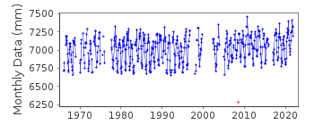
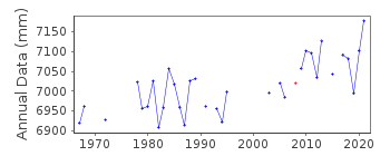
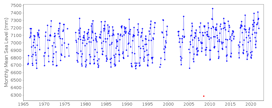
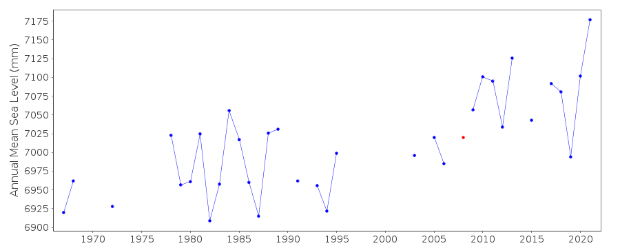
| Time span of data: | 1966 – 2021 |
| Completeness (%): | 78 |
| Date of last update: | 13 Mar 2023 |
| Green Arrow: | Current Station |
| Yellow Marker: | Neighbouring RLR Station |
| Red Marker: | Neighbouring Metric Station |
Please note: In many cases, the station position in our database is accurate to only one minute. Thus, the tide gauge may not appear to be on the coast.
Tide Gauge Data
Station Documentation
Link to RLR information.Documentation added 1991-06-11
Paradip 500/106 RLR(1981) is 10.3m below BM GTS.BM GTS is 5.04m above chart datum.Documentation added 1994-08-04
For a discussion of interannual variability of sea level along the coasts of Pakistan and India, see Clarke and Liu, Journal of Physical Oceanography, 24, 1224, 1994.Documentation added 2002-12-06
SMRC Newsletter Jul-Dec 2001 reports high E coast correlation with SOI and MSL. MSL is much higher during La Nina tropical cyclones than during El Nino.Documentation added 2012-05-17
Spike in the data August 2008 flagged as suspect. Although the data point was queried with the Survey of India they said the data value was correct.Data Authority
Survey of IndiaGeodetic and Research Branch
17 E.C. Road
Dehra Dun
PIN 248 001

![]()
![]()
![]()
