Data
- Obtaining
- Supplying
- High-Frequency
- Bottom Pressure Records
- Other Long Records
- GLOSS/ODINAFRICA Calibration Data
Donate
Donate to PSMSL
Data Notes
- Individual Station Data and Plot Notes
- Referencing the Data Set
- PSMSL Help File
- 2010 Changes to the PSMSL Data Files
Extracted from Database
11 Mar 2024
Station Information
| Station ID: | 1098 |
| Latitude: | 34.340556 |
| Longitude: | 134.906667 |
| Coastline code: | 643 |
| Station code: | 26 |
| Country: | JAPAN |
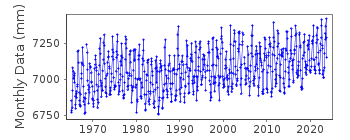
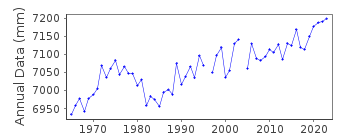
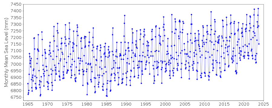
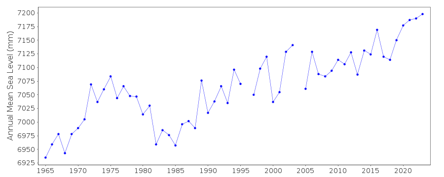
| Time span of data: | 1965 – 2023 |
| Completeness (%): | 99 |
| Date of last update: | 04 Mar 2024 |
| Green Arrow: | Current Station |
| Yellow Marker: | Neighbouring RLR Station |
| Red Marker: | Neighbouring Metric Station |
Please note: In many cases, the station position in our database is accurate to only one minute. Thus, the tide gauge may not appear to be on the coast.
Tide Gauge Data
Station Documentation
Link to RLR information.Documentation added 1991-06-11
Sumoto 643/026 RLR(1976) is 14.6m below Attached BM (i)Where two benchmarks have the same name the later one is suffixed.
Documentation added 2012-02-21
A massive earthquake magnitude 9.0 occurred at 14.46 JST (05.46 UTC) on Friday 11th March 2011 with the epicentre approx. 70 km east of the Oshika Peninsular . It was the most powerful earthquake to have hit Japan triggering a tsunami with waves up to 40.5m and travelling up to 10 km inland.Data Authority
Japan Meteorological Agency3-6-9 Toranomon, Minato City
Tokyo

![]()
![]()
![]()
