Data
- Obtaining
- Supplying
- High-Frequency
- Bottom Pressure Records
- Other Long Records
- GLOSS/ODINAFRICA Calibration Data
Donate
Donate to PSMSL
Data Notes
- Individual Station Data and Plot Notes
- Referencing the Data Set
- PSMSL Help File
- 2010 Changes to the PSMSL Data Files
Extracted from Database
11 Mar 2024
WARNING: QCFLAG EXISTS. PLEASE READ THE DOCUMENTATION.
Station Information
| Station ID: | 1089 |
| Latitude: | 34.681944 |
| Longitude: | 137.608889 |
| Coastline code: | 642 |
| Station code: | 126 |
| Country: | JAPAN |
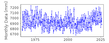
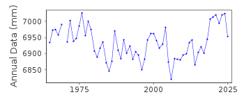
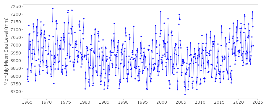
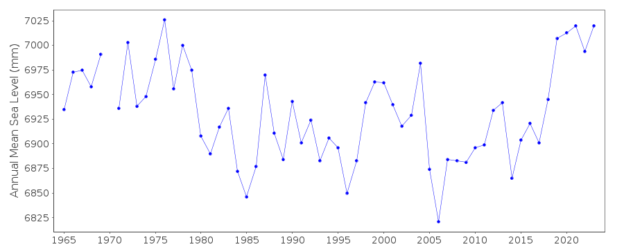
| Time span of data: | 1965 – 2023 |
| Completeness (%): | 99 |
| Date of last update: | 04 Mar 2024 |
| Green Arrow: | Current Station |
| Yellow Marker: | Neighbouring RLR Station |
| Red Marker: | Neighbouring Metric Station |
Please note: In many cases, the station position in our database is accurate to only one minute. Thus, the tide gauge may not appear to be on the coast.
Tide Gauge Data
Additional Data Sources (guide to additional data sources)
Fast Delivery Data from UHSLC station 356: hourly and dailyResearch Quality Data from UHSLC station 356: hourly and daily
Station Documentation
Link to RLR information.Documentation added 1991-06-11
Maisaka 642/126 RLR(1975) is 9.5m below Attached BMDocumentation added 1994-07-15
All records from approximately Maisaka (642/126) to Kushimoto (642/141) show large rates of rise of sea level, with large falls around 1980. Several factors might be at work. Emery and Aubrey (Sea Levels, Land Levels and Tide Gauges. Springer-Verlag. 1991. page 37) point to submergence caused by withdrawal of groundwater in the Nagoya area. In addition, Professor Minoru Odamaki informs us that sea levels in the area are well known to be affected by Kuroshio meanders. This is reported in Tsumura Kenshiro (1963) :" Investigation of the Mean Sea Level and its Variation along the Coast of Japan (Part I) ", Journal of Geodetical Society Japan, vol 9, 49-90,( in Japanese, with English abstract) and recently Kawabe M. (1980) : Sea level variations along the south coast of Japan and the large Meander in the Kuroshio. J. Oceanopgraphical Soc. Japan,36, 97-104.Documentation added 2003-11-20
Benchmark Attached BM (i) supercedes the previous benchmark Datum 1998 is 2.357m below Tokyo Peil.Documentation added 2012-02-21
A massive earthquake magnitude 9.0 occurred at 14.46 JST (05.46 UTC) on Friday 11th March 2011 with the epicentre approx. 70km east of the Oshika Peninsula of Tohoku. It was the most powerful known earthquake to hit Japan and triggered a tsunami with waves up to 40.5m and travelling up to 10km inland.Data Authority
Japan Meteorological Agency3-6-9 Toranomon, Minato City
Tokyo

![]()
![]()
![]()
