Data
- Obtaining
- Supplying
- High-Frequency
- Bottom Pressure Records
- Other Long Records
- GLOSS/ODINAFRICA Calibration Data
Donate
Donate to PSMSL
Data Notes
- Individual Station Data and Plot Notes
- Referencing the Data Set
- PSMSL Help File
- 2010 Changes to the PSMSL Data Files
Extracted from Database
11 Mar 2024
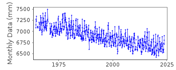
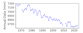
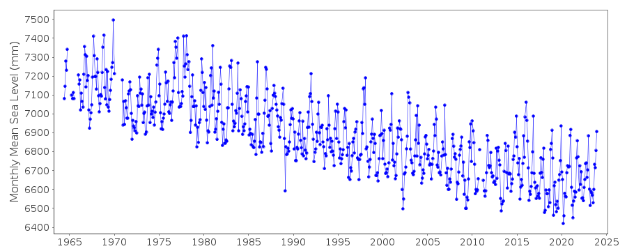
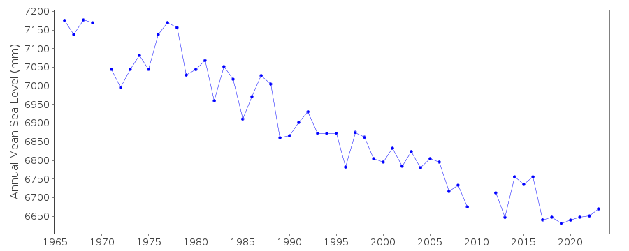
Station Information
| Station ID: | 1070 |
| Latitude: | 59.44 |
| Longitude: | -151.72 |
| Coastline code: | 821 |
| Station code: | 15 |
| Country: | UNITED STATES |
| Time span of data: | 1964 – 2023 |
| Completeness (%): | 96 |
| Date of last update: | 16 Jan 2024 |
| Green Arrow: | Current Station |
| Yellow Marker: | Neighbouring RLR Station |
| Red Marker: | Neighbouring Metric Station |
Please note: In many cases, the station position in our database is accurate to only one minute. Thus, the tide gauge may not appear to be on the coast.
Tide Gauge Data
Additional Data Sources (guide to additional data sources)
Nearby GNSS Stations from SONEL: SELDResearch Quality Data from UHSLC station 561: hourly and daily
Station Documentation
Link to RLR information.Documentation added 1991-06-11
Seldovia 821/015 RLR(1972) is 12.2m below BM13Documentation added 1992-04-02
South Alaskan Coastline is Earthquake prone - E.G. Magnitude 9.2 earthquake of 28 March 1964 - See Savage and Plafker, JGR,96(B3), 4325-4335, 1991Documentation added 2011-11-24
Using information from the NOAA website the RLR diagram has been revised.Former Primary benchmark BM 13 10.458m relative to gauge datum on NOAA is NO 13 1964 with a value of 10.438m in the 1999 report and 10.432m in the 2011 report. Primary benchmark is now BM 19 1967 11.272m relative to gauge datum. This benchmark has the value 11.272m in both reports and also appears on the original RLR diagram as a secondary benchmark.Documentation added 2017-02-07
The complete dataset for Seldovia has been revised by NOAA. A foot note at the base of the Bench Mark information refers to certain areas experiencing rapid land movement due to uplift or subsidence.Data Authority
N.O.A.A. / N.O.S.N/oes33, Ssmc4, Room 6531
1305 East-West Highway
Silver Spring,
MD 20910

![]()
![]()
![]()
