Data
- Obtaining
- Supplying
- High-Frequency
- Bottom Pressure Records
- Other Long Records
- GLOSS/ODINAFRICA Calibration Data
Donate
Donate to PSMSL
Data Notes
- Individual Station Data and Plot Notes
- Referencing the Data Set
- PSMSL Help File
- 2010 Changes to the PSMSL Data Files
Extracted from Database
11 Mar 2024
Station Information
| Station ID: | 1051 |
| Latitude: | 43.466242 |
| Longitude: | -3.765541 |
| Coastline code: | 200 |
| Station code: | 12 |
| Country: | SPAIN |
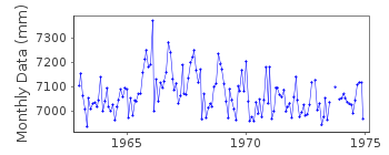
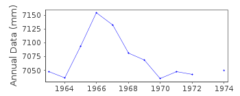
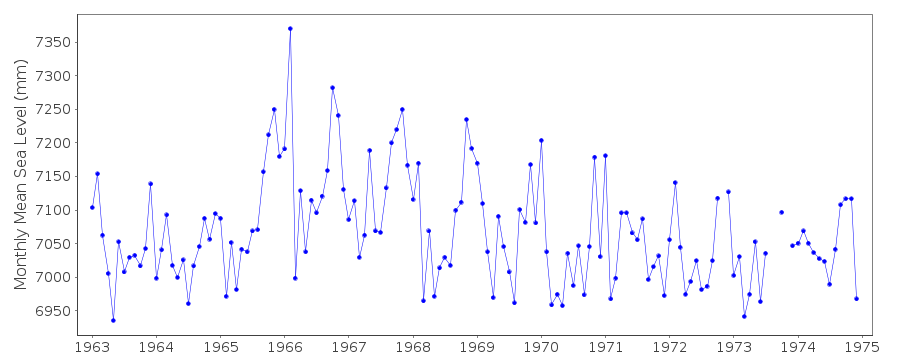
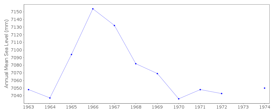
| Time span of data: | 1963 – 1974 |
| Completeness (%): | 97 |
| Link to ellipsoid: | Available |
| Date of last update: | 01 Jan 1980 |
| Green Arrow: | Current Station |
| Yellow Marker: | Neighbouring RLR Station |
| Red Marker: | Neighbouring Metric Station |
Please note: In many cases, the station position in our database is accurate to only one minute. Thus, the tide gauge may not appear to be on the coast.
Tide Gauge Data
Additional Data Sources (guide to additional data sources)
Nearby GNSS Stations from SONEL: CANTNearby Real Time Stations from VLIZ: san2
Station Documentation
Link to RLR information.Documentation added 1991-06-11
Santander II 200/012 RLR(1964) is 14.3m below BM NAP G 854Documentation added 1993-07-12
Santander II 200/012 RLR(1964) is 14.3m below BM NAP G 854Santander II is an historic station last data 1974
Documentation added 2005-05-23
A paper by Marcos et al (JGR Volume 11, 2005) provides an overviewof the tide gauge records on the northern coast of Spain.
Data Authority
Instituto Geográfico NacionalRed de Infraestructuras Geodésicas
General Ibáñez de Ibero, 3
28003, Madrid

![]()
![]()
![]()
