Data
- Obtaining
- Supplying
- High-Frequency
- Bottom Pressure Records
- Other Long Records
- GLOSS/ODINAFRICA Calibration Data
Donate
Donate to PSMSL
Data Notes
- Individual Station Data and Plot Notes
- Referencing the Data Set
- PSMSL Help File
- 2010 Changes to the PSMSL Data Files
Extracted from Database
11 Mar 2024
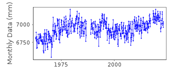
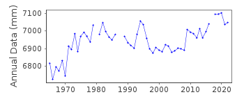
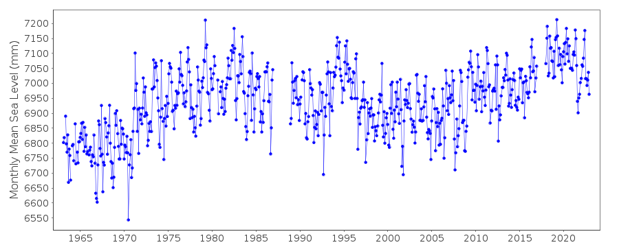
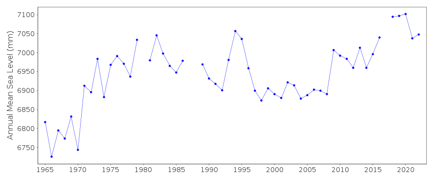
Station Information
| Station ID: | 1032 |
| Latitude: | -22.896667 |
| Longitude: | -43.166667 |
| GLOSS ID: | 195 |
| Coastline code: | 874 |
| Station code: | 92 |
| Country: | BRAZIL |
| Time span of data: | 1963 – 2022 |
| Completeness (%): | 94 |
| Date of last update: | 11 Aug 2023 |
| Green Arrow: | Current Station |
| Yellow Marker: | Neighbouring RLR Station |
| Red Marker: | Neighbouring Metric Station |
Please note: In many cases, the station position in our database is accurate to only one minute. Thus, the tide gauge may not appear to be on the coast.
Tide Gauge Data
Additional Data Sources (guide to additional data sources)
Nearby GNSS Stations from SONEL: ONRJFast Delivery Data from UHSLC station 280: hourly and daily
Research Quality Data from UHSLC station 709: hourly and daily
Research Quality Data from UHSLC station 280: hourly and daily
Station Documentation
Link to RLR information.Documentation added 1993-04-02
prior to 1991 acode=B2Documentation added 2008-08-18
2007 MSL values supplied directly from Marcelo. Because of thisit was decided to use the values supplied for 2006
from Marcelo rather than the Hawaii values. Although
small there were some differences. A copy of the previous
values is in the country file.
Documentation added 2010-09-13
Data for Ilha Fiscal is now supplied by Rosuita Helena Roso. The 2009 monthlymean sea level data was calculated from SE200 processed hourly data. Gaps for
3-8 Sept.,12-15 Sept.,14-19 Oct. and 20-21 Oct. were filled with data from the
second data sensor - the radar 5min sampling sensor.
Documentation added 2012-05-15
Rosuita Helena Roso has now been replaced by Cesar Henrique de Oliveira BorbaCapitao-Tenente (T), Encarregado Secao de Mares, CENTRO DE HIDROGRAFIA DA
MARINHA (CHM).
Using datum information supplied Ilha Fiscal was made RLR. Primary benchmark is
RN2-DHN
4.924m above TGZ RLR factor 4.676m.
Documentation added 2014-04-01
The person responsible for the supply of sea level data values from the Brazilian Network is now Lieutenant Juarez. From 2011 the Kalesto sensor has been defined as the main sensor at Ilha Fiscal.Data Authority
Rua Barao de Jaceguai,S/No - Ponta da Armacao

![]()
![]()
![]()
