Data
- Obtaining
- Supplying
- High-Frequency
- Bottom Pressure Records
- Other Long Records
- GLOSS/ODINAFRICA Calibration Data
Donate
Donate to PSMSL
Other Links
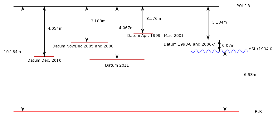
Revised Local Reference (RLR) Diagram for ENGLISH BAY (ASCENSION ISLAND)
Station ID: 1831

If the image above appears blurry, or you would like to see a larger image, please view the full-sized image of the RLR diagram.
Datum information
Add 7.000m to data values 1993-1998 to refer to RLR
Add 7.008m to data values 1999-2001 to refer to RLR
Add 6.996m to data values for 2005 to refer to RLR
Add 7.000m to data values 2006-2007 to refer to RLR
Add 6.996m to data values 2008-2010 to refer to RLR
Add 6.130m to data values for 2010 to refer to RLR
Add 6.117m to data values 2011 onwards to refer to RLR
RLR is 10.184m below primary benchmark POL 13
Ellipsoidal information from SONEL (explanation)
| GNSS | Solution | Height | Velocity | Epoch | GNSS Start | GNSS End | Distance |
|---|---|---|---|---|---|---|---|
| ASC1 | ULR7a | 8.196 ± 0.015 | -0.37 ± 0.30 | 2007.6726 | 1996-04-21 | 2007-09-03 | 7112 |
| ASCG | NGL14 | 8.172 ± 0.024 | -0.63 ± 0.81 | 2020.0000 | 2015-09-18 | 2023-03-23 | 6400 |
| ASC1 | NGL14 | 8.200 ± 0.015 | Not robust | 2007.6715 | 1996-04-21 | 2007-09-03 | 7112 |
| ASCG | ULR7a | 8.182 ± 0.024 | 0.21 ± 0.26 | 2020.0000 | 2015-09-18 | 2023-03-23 | 6400 |
| ASC1 | GT3 | 8.207 ± 0.015 | Not robust | 2007.6726 | 1996-04-21 | 2007-09-03 | 7112 |
| ASC1 | JPL14 | 8.195 ± 0.016 | Not robust | 2020.0000 | 1996-04-21 | 2007-09-03 | 7112 |


