Data
- Obtaining
- Supplying
- High-Frequency
- Bottom Pressure Records
- Other Long Records
- GLOSS/ODINAFRICA Calibration Data
Donate
Donate to PSMSL
Other Links
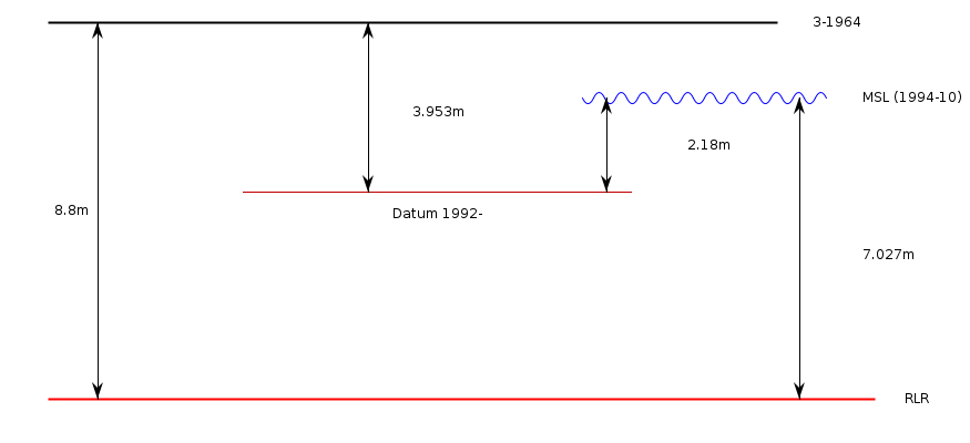
Revised Local Reference (RLR) Diagram for WINTER HARBOUR
Station ID: 1799

If the image above appears blurry, or you would like to see a larger image, please view the full-sized image of the RLR diagram.
Datum information
Add 4.847m to all data values to refer to RLR
RLR is 8.800m below primary benchmark 3-1964
Ellipsoidal information from SONEL (explanation)
| GNSS | Solution | Height | Velocity | Epoch | GNSS Start | GNSS End | Distance |
|---|---|---|---|---|---|---|---|
| HOLB | JPL14 | -22.547 ± 0.003 | 2.21 ± 0.41 | 2020.0000 | 1992-09-08 | 2023-03-23 | 15518 |
| HOLB | ULR7a | -22.554 ± 0.005 | 2.41 ± 0.24 | 2020.0000 | 1992-09-08 | 2023-03-23 | 15518 |
| HOLB | GT3 | -22.443 ± 0.008 | 2.69 ± 0.30 | 2020.0000 | 1992-09-08 | 2023-03-23 | 15518 |
| HOLB | NGL14 | -22.546 ± 0.004 | 2.25 ± 0.56 | 2020.0000 | 1992-09-08 | 2023-03-23 | 15518 |


