email: murphycm@aston.ac.uk
Tide gauges provide an opportunity to calibrate altimetric satellites without the need for additional in-situ equipment. The results achieved using this method come close in accuracy to sophisticated calibration techniques which require extensive instrumentation to be placed under a suitable ground-track of the satellite. The UK tide gauges are situated such that many lie near to the ground-tracks of both the European Space Agency satellite ERS1 and the NASA/CNES satellite TOPEX/POSEIDON. Tide gauge data combined with the excellent models for tides, geoid and storm surge in the area of the United Kingdom provide an opportunity for calibration of these satellites.
Altimetric satellites typically exhibit a bias which is usually attributed to electronic delays in the altimeter itself. This bias will cause the altimeter to measure consistently too long or too short. As this bias is a constant offset, it may be ignored in relative work, as sea surface topography features will be visible whether the altimetry is corrected for bias or not. When absolute sea surface elevation is required and the altimeter ranges are not corrected for the range bias, the bias will translate as error directly into the derived elevation. If the bias is known for several altimetric satellites which are operational at different times over a long period, the combined altimetry may be used as a more powerful dataset. It is also important to monitor any temporal drift in the bias of a satellite as this could be mistakenly interpreted as sea level change.
This calibration technique exploits the fact that the bias is manifested as a misclosure between the ocean surface elevation as observed from the satellite and the elevation at the same point as calculated in-situ.
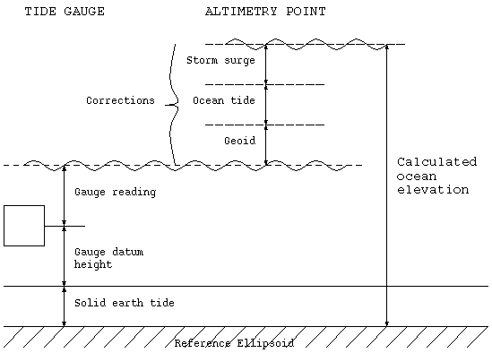
A tide gauge is used to derive the calculated ocean elevation. The elevation of the tide gauge datum above some reference must be determined accurately, for instance by GPS survey. Raw ocean surface elevations as measured by the tide gauge are corrected to allow for change in the ocean elevation between the gauge and the point on the ground-track of the satellite at which the altimetry reading is taken. Principal corrections applied are those for the geoid and the ocean tide. A model for the inverse barometer effect (storm surge) may also be applied although the magnitude of the contribution of this to the bias rarely exceeds the errors in most practical configurations. Finally the whole system is raised or lowered as a correction for the solid earth tide. The configuration for the calculated ocean elevation is shown in Figure 1: The Calculated Ocean Elevation.
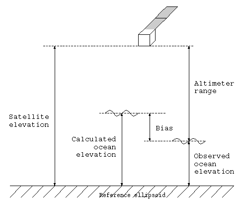
There are two contributors to the observed ocean elevation. The first is the corrected altimeter range and the second is the satellite elevation above the same reference as that used for the tide gauge datum elevation. The raw altimeter range has corrections applied for instrumental effects such as propagation delays. A precise satellite ephemeris is used to generate the satellite elevation above the reference. The radial component of this is critical as errors due to the ephemeris determination will be entirely caused by this component alone. Figure 2: The Observed Ocean Elevation and Bias depicts the calculation of the observed ocean elevation and links this with the calculated ocean elevation to give the bias. The bias shown is a conventionally considered to be positive, i.e. a positive bias causes the altimeter to measure too long.
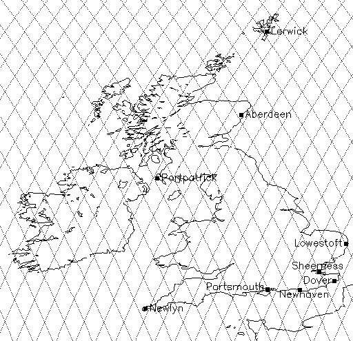
This document describes the calibration of ERS-1 during its multidisciplinary 35-day repeat phase (15 May 1992 until 15 December 1993) and the calibration of TOPEX/POSEIDON during the period from launch until cycle 74 (28 September 1992 until 25 September 1994.) The ERS-1 ground-track over the UK for this period in relation to the principal tide gauges of the UK are shown in Figure 3: ERS-1 Ground-Track for the Multidisciplinary Phase.
Similarly, the ground-track for TOPEX/POSEIDON is shown in Figure 4: TOPEX/POSEIDON Ground-Track.
The tide gauge at Newhaven is an excellent choice for this calibration as the ground-tracks of both satellites pass very close to it and the models for the geoid and the tide are reliable. In addition, the satellite laser ranging (SLR) facility is close by at Herstmonceux. The SLR station is important for radial correction of the orbit elevations.
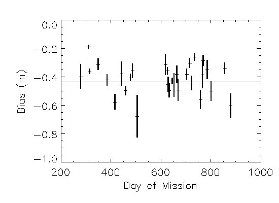
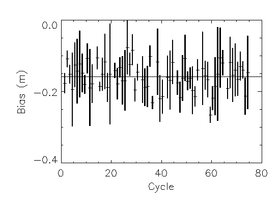
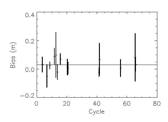
Calibration was carried out as described for the two satellites using data from the Newhaven tide gauge. TOPEX/POSEIDON consists of two independent altimeters and so one bias for each altimeter was extracted. Ample altimetry was found in the English Channel close to the Newhaven site and corrections were applied for the geoid and storm surge. The precise orbits for ERS-1 were generated at Aston University. Satellite elevations were taken from the altimetry geophysical data records for TOPEX/POSEIDON as these were validated with the Aston orbits and found to be of the required accuracy. The calibration resulted in many bias values which could be averaged on a pass basis or over the entire period of the exercise. The three graphs presented in figures 5, 6 and 7 show the pass biases for ERS-1, TOPEX and POSEIDON respectively along with the RMS spread for each pass and the average of all biases. Click here to see
and Figure 7: POSEIDON Biases.
Biases were derived for the three altimeters. The final biases obtained after averaging were -43.2 cm for ERS-1, -15.8 cm for TOPEX and +3.1 cm for POSEIDON.